
 |
Detailed maps of the Gilf Kebir - Uweinat area |
Survey of Egypt 1:500,000 series
The Survey of Egypt published the 1:500,000 series maps covering the whole of egypt in the early 1900s. The last to be completed were the extreme western swheets, covering all of the Libyan Desert in Egypt to the South of Siwa and the West of the main oases. Much of the survey work involved was made by Beadnell, Clayton, Bagnlod & Almásy in the early thirties. There were some updates during the early phases of the War, most of the presently available sheets were last updated in 1941/42. The same series are still available at the Egyptian Survey Institute at Giza, though unfortunately the recent reprints are of a much inferior quality (smudged labels, misaligned/missing colors, etc.) than the original ones from the forties. Due to the low demand, amazingly till recently a stock of the original 1942 edition Uweinat & Baharya sheets were still available at Giza, however now all are available only as reprints.
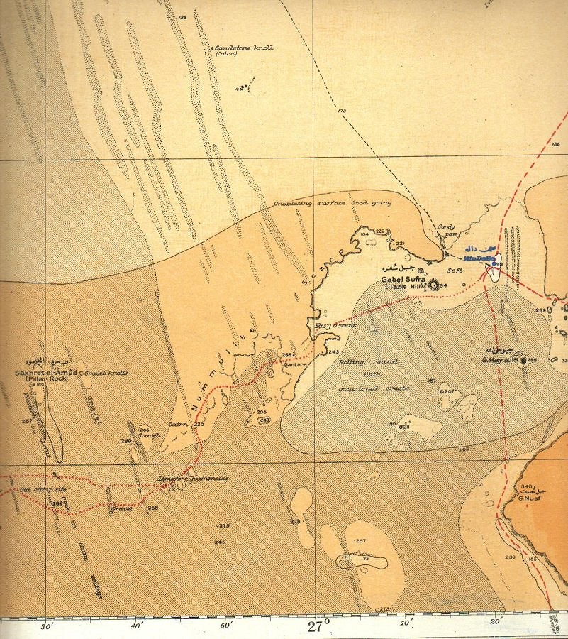
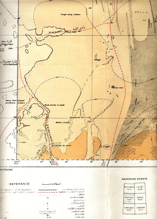
These maps are the best available for desert navigation in the area. While they have a limited accuracy (some points 2-3 kms off true position) due to the inherent errors in the early survey methods, the nature of the actual terrain is very well marked, which is more important than accuracy (as all major landmarks are well visible from 10-20 kms). The maps are full of labels like 'hard sand plain, good going', 'loose rock slabs, very bad going', 'easy dune crossing' which makes route planning much easier, than a more detailed map but which has no reference to the actual terrain. Three sheets cover the relevant area inside Egypt:
 |
BAHARYA N29o00' E24o40' to N26o45' E29o00' Survey of Egypt 1941 (41/395) reprinted 1998 This sheet covers most of the Great Sand Sea, from just south of Siwa (including the chain of small oases at the south edge of the Qattara depression) till the route from Ain Dalla to Big Cairn, as well as the Oases of Baharya and Farafra. Available (reprint) for EUR 25/USD 30 each. |
 |
DAKHLA N26o45' E24o40' to N24o15' E29o00' Survey of Egypt 1941 (T41/90) reprinted 1996 This sheet covers the Southern part of the Great Sand Sea, till the Northern tip of the Gilf Kebir, as well as the Oases of Abu Mungar and Dakhla. Available (reprint) for EUR 25/USD 30 each. |
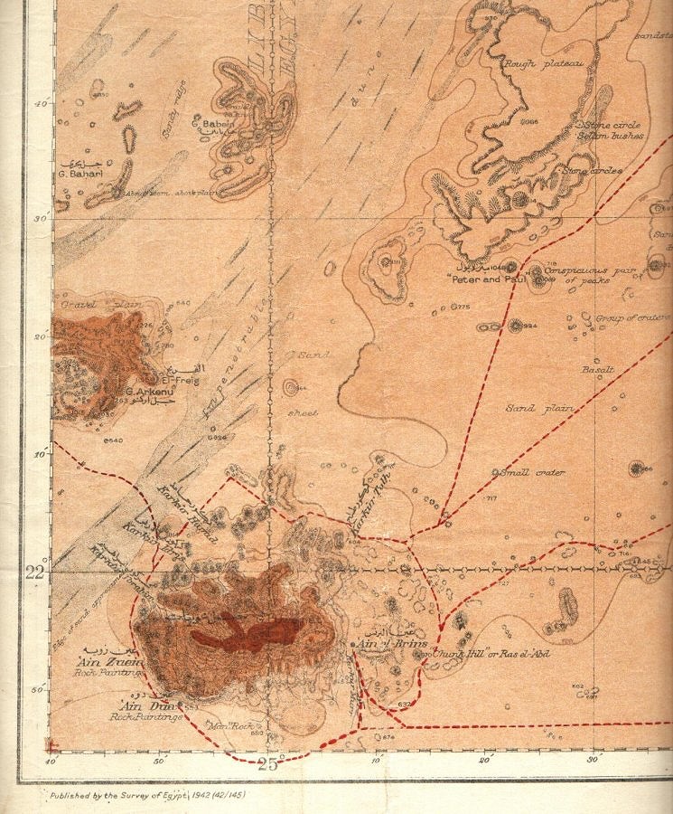 |
UWEINAT N24o15' E24o40' to N21o45' E29o00' Survey of Egypt 1942 (42/145) reprinted 2001 This sheet covers the majority of the Kilf Kebir, Jebel Uweinat, and the Selima Sand Sheet to the east till Bir Terfawi. Available (reprint) for EUR 32/USD 40 each. |
While the LRDG completed the surveying of the adjacent areas in Libya in 1941/42, and the corresponding maps have been produced, I don't know of any source for these. The earlier Italian maps of SE Libya (with one exception) show very little detail (as was noted by Almásy in 1942 with quite some annoyment), the best available of the area are the Russian 1:500,000 series.
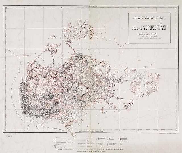
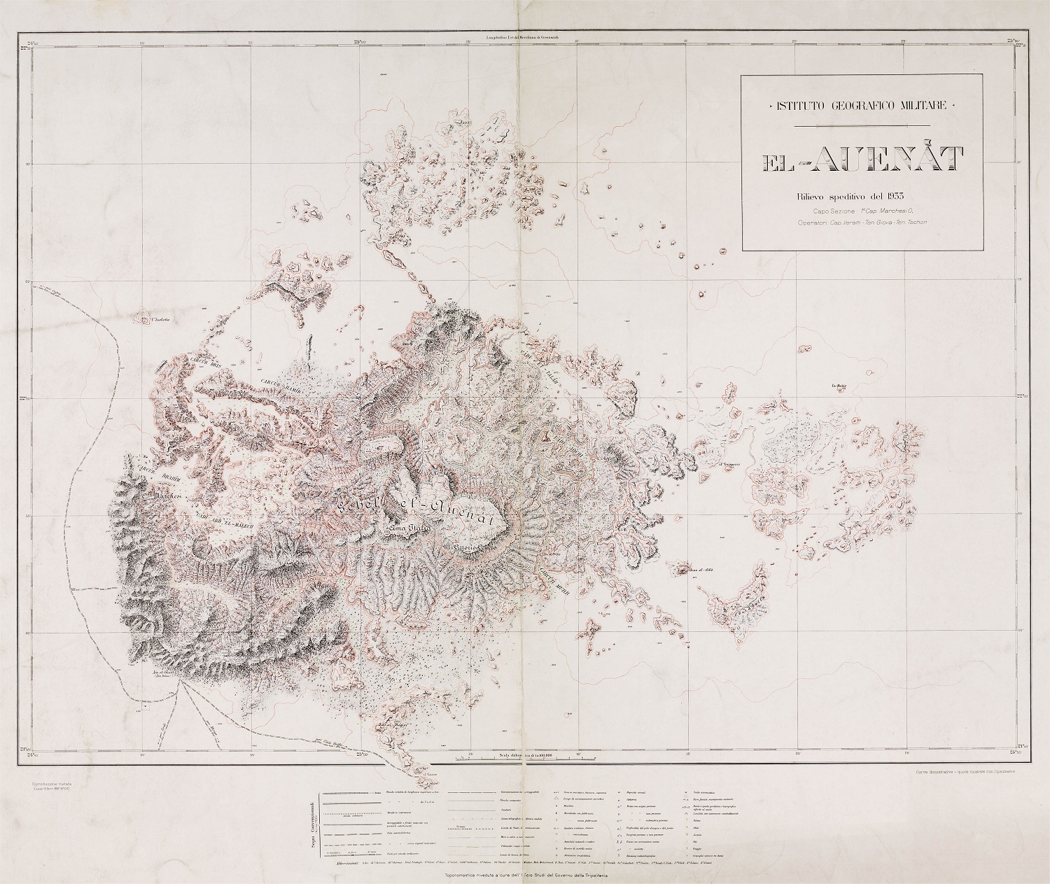
Italian 1:100,000 Uweinat
The 1933 Marchesi Expedition produced a very detailed (though rather inaccurate) 1:100,000 map of Jebel Uweinat. Digital or hardcopies of the original may be obtained from the Instituto Geografico Militare library in Firenze.
 Hi-res version (665 kb) |
El Auenàt N22o15' E24o45' to N21o45' E25o30' Instituto Geografoco Militare, Firenze, 1933 This map is mainly for historical interest, the interior of the mountain is shown rather inaccurately, as revealed by detailed satelite images. Nevertheless, it remains the only detailed published map of Jebel Uweinat, and it must have taken an immense effort to compile it. The track of the ascent of the Marchesi party to Cima Italia is marked, almost perfectly matching our first ascent with Bernhard in 2001. |
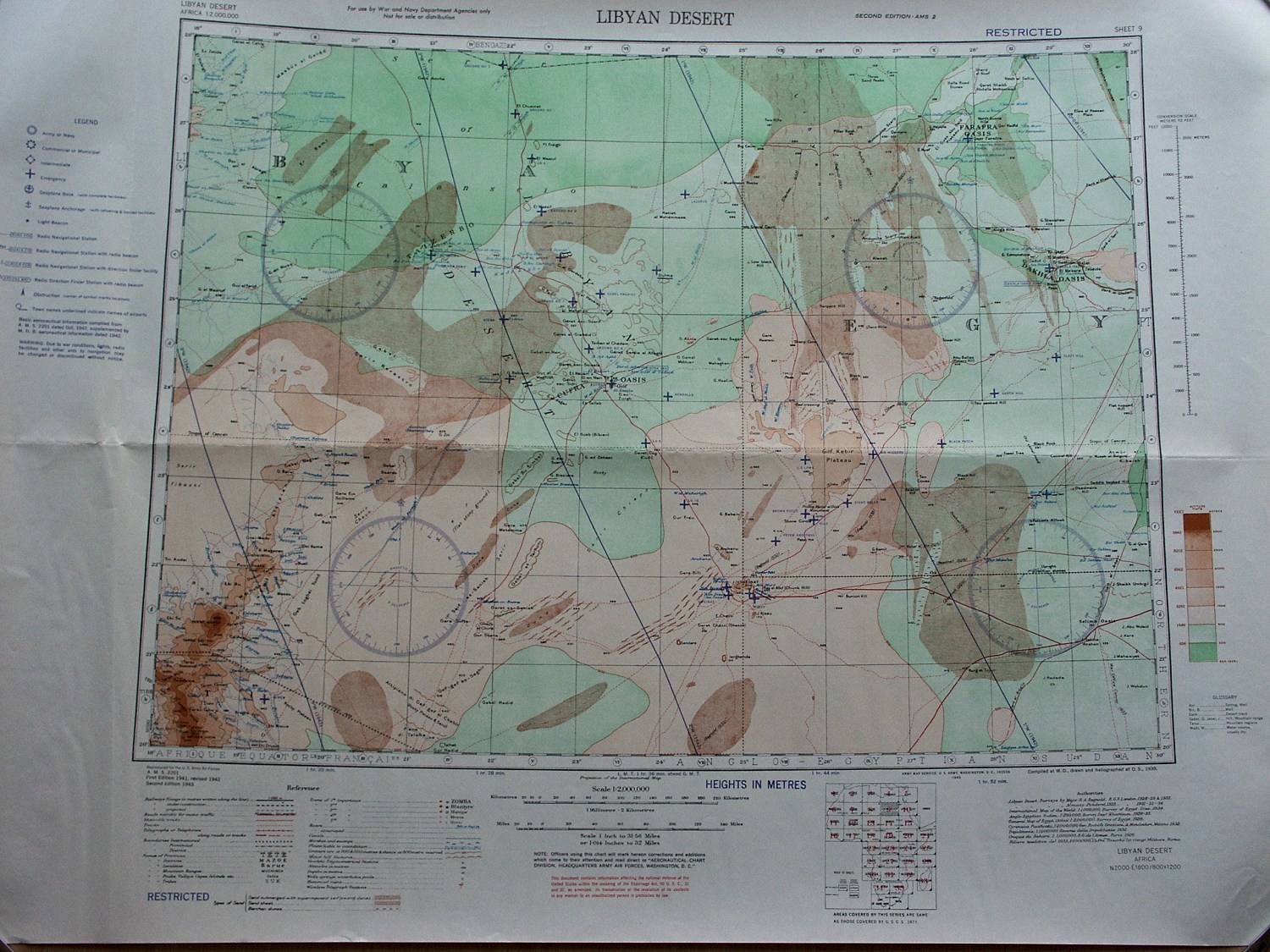
Army Map Service 1:2,000,000 series
During WWII the US Army Map Service produced a very high quality 1:2M air navigation chart series. As at the time navigation was mainly visual, these maps show much more topographical detail than todays TPC charts.
The maps were based on existing other maps, the ones of Africa were made using mostly French and British maps of the areas. While rare, they can be obtained occasionally from map specialists in the US.
 Hi-res version (492 kb) |
AMS 2201 Libyan Desert N28o00' E18o00' to N20o00' E30o00' Army Map Service, Washington D.C., 1942 This sheet covers most of the Libyan Desert, centered on Kufra. Of particular historical interest are the many emergency landing fields shown accross the desert (blue crosses), with their names. Interestingly the Wadi Sora airfield is not marked, so it must have been established in 1942 after the map was printed. Another interesting feature is the lack of the Calanascio Sand Sea east of the Kufra - Jalo track. This must have been taken over from Italian maps, this was the error that cost Almásy two week's delay during his 1942 raid. |
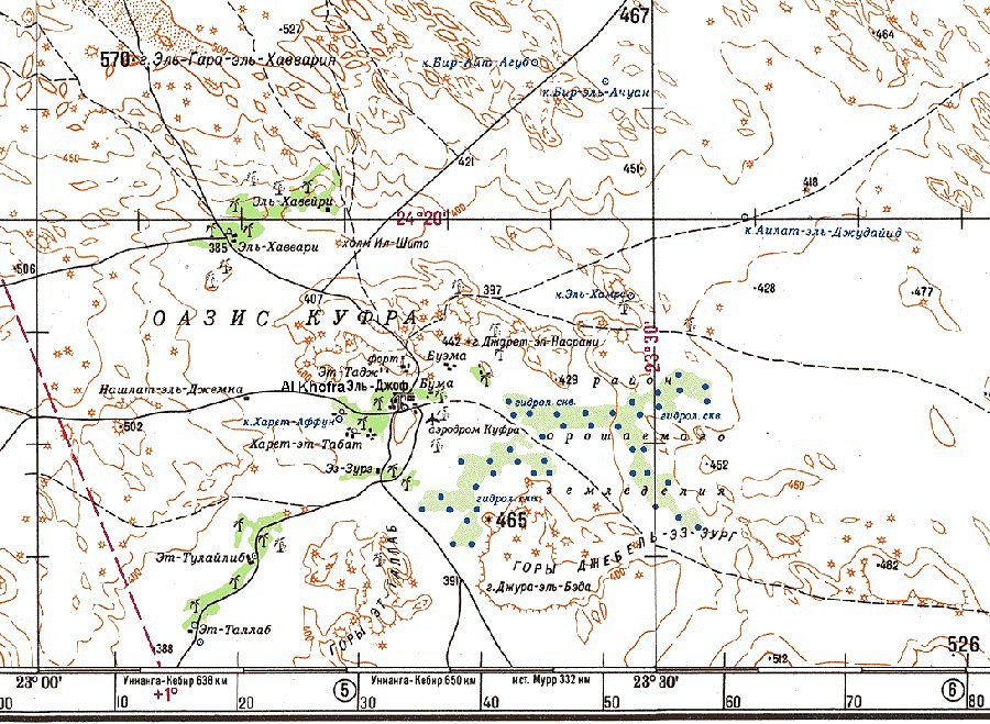
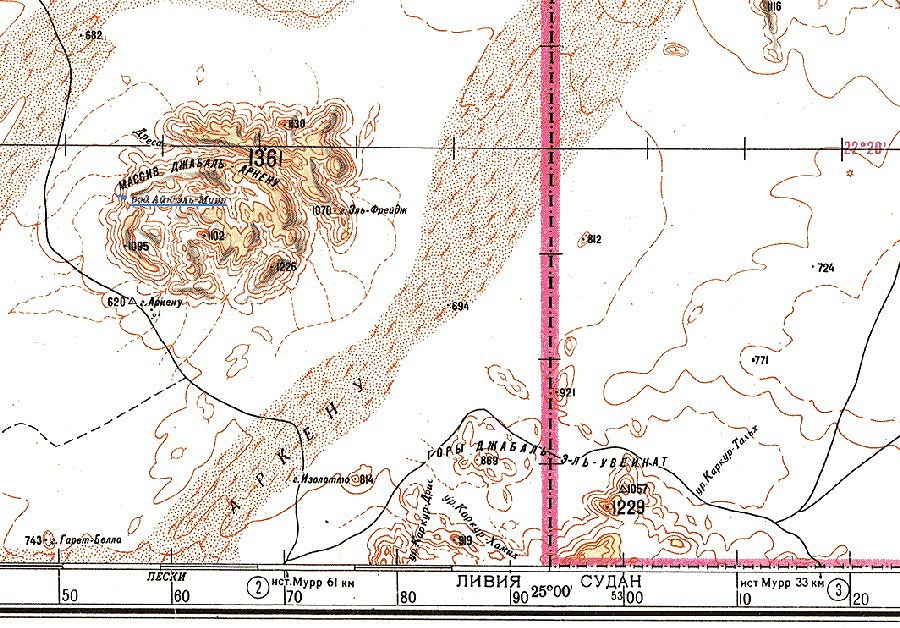
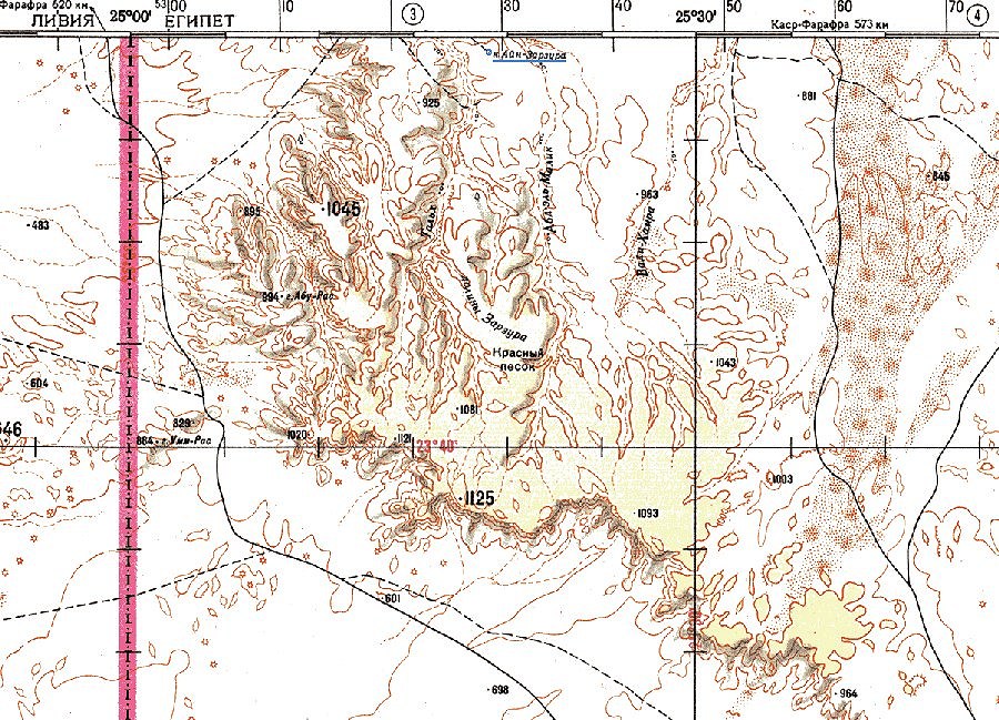
Russian 1:500,000 series
During the seventies and eighties the Soviet military produced a global 1:500,000 (and in some areas 1:250,000) map series based on aereal and satelite photos. After 1990 these have become freely available. Of the Eastern Sahara only the 1:500,000 series are available, you can get the calibrated maps of all Africa on CD together with associated navigation software from Joachim Bungert.
As the maps are based on aereal and satelite images, they are very accurate in terms of position, but rather difficult to read (apart of the cyrillic script) due to the very dense contour lines, and the use of symbols to mark certain terrain features. There is very little "feel" for the actual encountered terrain. Usually areas marked as sand or dunes prove to be quite easily passable, whereas on the Survey of Egypt only real big dune fields are marked as such. Also many features not recognisable from the air are marked or labelled on pure imagination. Eg. the spring at Arkenu is marked totally incorrectly, and a "fort" symbol is used to mark "Three Castles" :)
Each sheet is 2' tall, 3' wide. The relevant sheets are (coordinates top left corner):
 |
 |
 |
