
Hi-Res Landsat Images of the Libyan Desert
Hitherto the best freely available satelite images of the Libyan Desert and the Sahara in general were the Landsat preview images available on the European Space Agency website, offering approximately 300 metre to a pixel resolution.
Now, courtesy NASA, 25 metre resolution Landsat images covering approximately 60% of the land surface area of the world (including all Africa) are available on the web, completely free ! This is coupled with the Lizardtech MrSid software that allows practically instant viewing and zooming of 45 Mb image files (that would be probably 200-300 megs in jpg) with none of the original resolution lost.
The images are available at the NASA Earth Sciences Applications Directorate website. There is only one image available for each position, and the images are quite old (6 - 10 years). This means that the images don't show more recent roads and construction, but the main desert features will of course not change.
The images can be viewed and zoomed on the website, or the raw MrSid images can be downloaded (about 45 megs each). To view them, you need the MrSid Image Viewer, a free plugin available from Lizardtech.
The following is a sampling of various features in the Libyan desert, clipped from the larger images at different resolutions (metres/pixel):

|
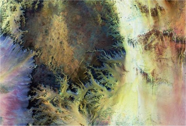
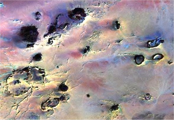
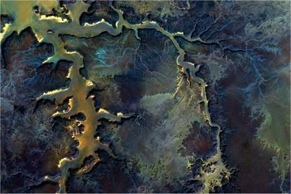
The central Libyan Desert
Resolution: 800 metres Image centered a little to the South-east of the Gilf Kebir. The two large dark masses in the upper left quadrant are the two halves of the Gilf Kebir plateau. In the lower left quadrant the in-line three mountains are Arkenu, Uweinat and Kissu. The lower right quadrant shows a series of scarps, while the lower right is occupied by the perfectly flat Selima Sand Sheet, the only visible features being light coloured dune fields. |
|
The South-eastern Gilf Kebir
Resolution: 200 metres A closer view of the South-east half of the Gilf Kebir, with the adjacent scarps running to the east. The large wadis along the eastern side are clearly visible. |
|
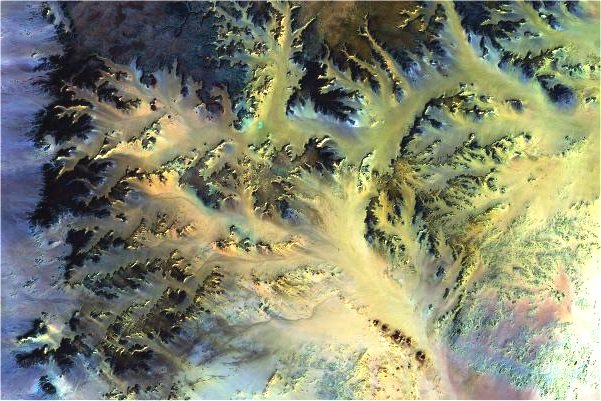
The Southern Gilf Kebir
Resolution: 100 metres The broad wadi at the upper centre of the image, fully crossing the Gilf from east to west is Wadi Wassa. Wadi Firaq is the much shorter and narrower parallel wadi. The prominent group of in-line hills at bottom right are "Eight Bells". |
|
Wadi Bakht
Resolution: 25 metres A maximum resolution image of the head of Wadi Bakht. The blocking dune is clearly visible at the centerline of the image. |
|
Wadi Ard al Akhdar
Resolution: 25 metres A maximum resolution image of the head of Ard al Akhdar. The playa once containing the prehistoric lake is the large basin near bottom center. The dark circular patches are basalt hills. |
|
Jebel Uweinat
Resolution: 100 metres The image is centered on the peak, at 1934 metres. The circular western part, lying in Libya, is composed of granites, while the east is made of sandstones resting on an archaic basement. |
|
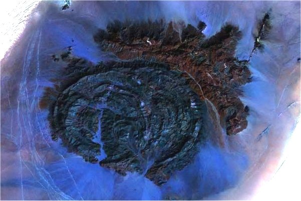
Karkur Talh
Resolution: 25 metres Maximum resolution image of Karkur Talh, the main valley system draining the sandstone part of Jebel Uweinat. At this resolution it is possible to vaguely make out vegetation in the central parts of the main valley. Many of the lesser side wadis remain unexplored. |
|
Jebel Arkenu
Resolution: 50 metres Arkenu, like Uweinat, is also made of a series of granite ring complexes in the west, and an adjacent sandstone slab to the North-east. The colour difference between the two types of rock is quite distinct on this image. The tracks of the truck convoys traveling between Kufra and el Fasher in Sudan are clearly visible to the west of the mountain. |
|
Jebel Babein and Unnamed Plateau
Resolution: 100 metres To the left, Jebel Babein, a much eroded granite complex straddling the Egypt-Libya border. To the right, a large low unnamed plateau, composed of basement rocks. Jebels Peter & Paul are just visible at the bottom right of the image. The bright band between them is the dune belt that also separates Arkenu and Uweinat. |
|
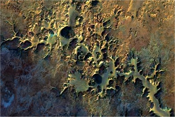
Clayton's Craters
Resolution: 25 metres The circular crater like features are clearly visible at the right of the image. At bottom left, another large circular feature, unrecognisable on the ground, can be seen amongst dark lines that are dikes and ridges criss-crossing the whole area. |
|
The 'Aqaba pass
Resolution: 25 metres The pass is the straight wadi slightly to the upper left of the centre of the image. The other wadi to the lower right is probably the one Almásy refers to as the "Penderel wadi". |
|
The Wadi Sora promontory
Resolution: 12.5 metres This image is enhanced to twice original resolution by the MrSid software. While new information is not added, the enhancement makes smaller features better visible. Enhancement is practical up to 3x original resolution, resulting in usable images with 3 metre/pixel resolution. In this image all the small side wadis are clearly and distinctly visible. |
|
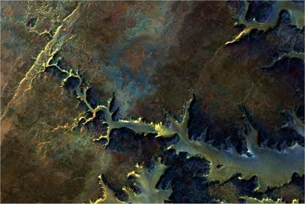
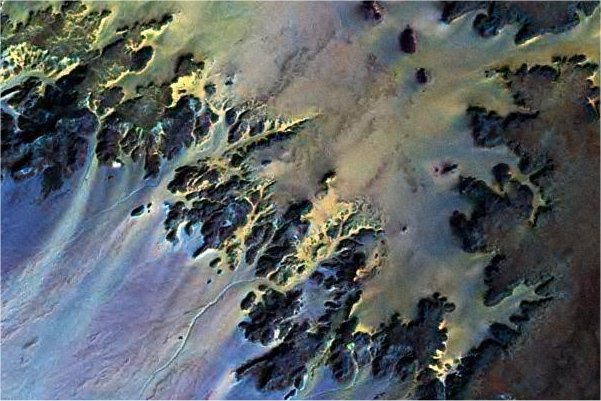
The Northern Gilf Wadis
Resolution: 100 metres The image shows the two main branches of Wadi Abd el Melik, and the broader Wadi Hamra to the East. The bright area at the right of the image are the dunes blocking the middle of the "Gap" |
|
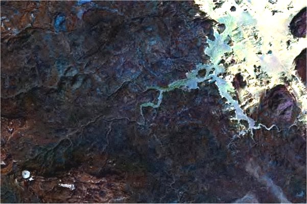
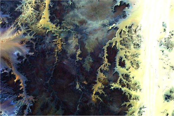
Wadi Abd el Melik
Resolution: 25 metres A maximum resolution detail of the previous image, showing the confluence of the two branches of Wadi Abd el Melik. |
|
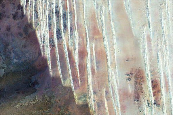
The "Gap" dunes and Jebel Almásy
Resolution: 100 metres To the left the dune range blocking the "Gap". At this resolution it is possible to make out the individual dunes, allowing a plotting of possible navigable routes through them. Jebel Almásy is the isolated round darker patch to the north of the larger plateau in the left center of the image. To the right, the longitudional dunes of the Great Sand Sea. |
|
Silica Glass Area
Resolution: 100 metres The dunes of the Great Sand Sea terminate abruptly at the foot of the low plateau of the Northern Gilf. Libyan Desert Glass can be found in an oval area approximately in the center of the image, in the large interdune corridors. |

|
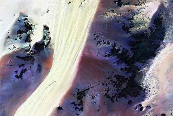
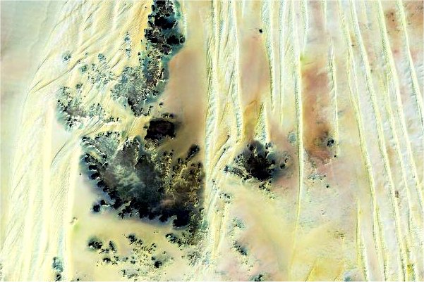
The Great Sand Sea
Resolution: 200 metres This image is taken to the west of Bir Abu Mungar. To the right, the firm ground still appears betwen the dune ranges. Rohlf's "Ammonite Scarp" is visible near the bottom. To the left, sand fills the interdune corridors. |
|
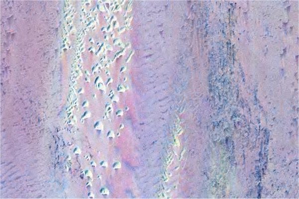
Hill With Stone Circles on Top
Resolution: 12.5 metres An enhanced resolution image of the "Hill With Stone Circles" area, showing the long trailing dunes behind each hill, and the distinct dark patch that was the prehistoric lake bottom. The pink yardangs are in the darkets area, right of the dune in the center. |
|
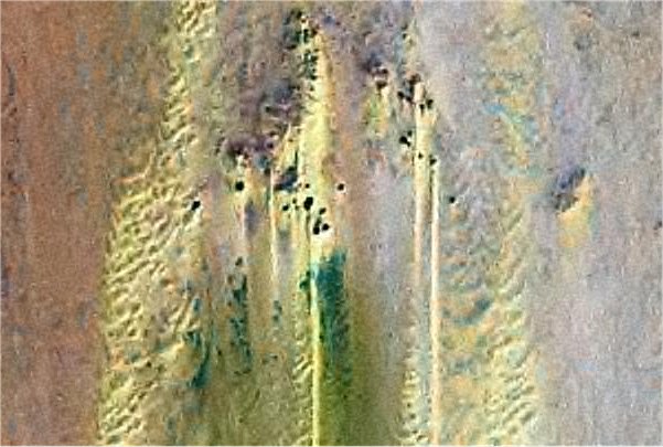
Abu Hussein Dunes
Resolution: 25 metres The Abu Hussein dune field on the Selima Sand Sheet. Individual barchans clearly stand out. |
|
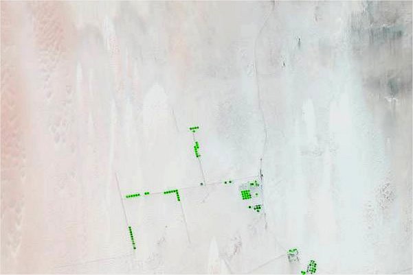
East Uweinat irrigation project
Resolution: 300 metres This is image is not from the NASA website, but from a current Landsat preview image. On the old photo from the NASA site there is nothing in this area, about 50 kilometres to the south of Bir Terfawi, but sand. Now, the large circular irrigation fields and access roadways are clearly visible even in the low resolution of the preview image. |
|
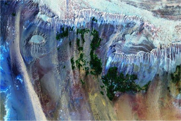
Dakhla Oasis
Resolution: 100 metres Dakhla oasis, as it appeared a decade ago. The road leading south can be made out, as well as the green areas. The only feature notably missing is the large reservoir that was built near Mut some years ago. |
|
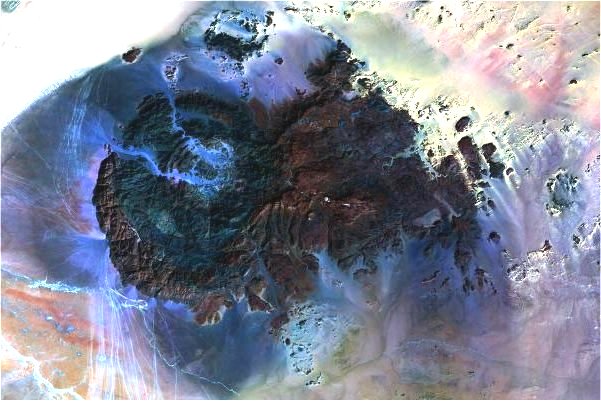
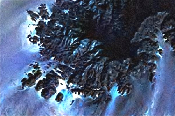
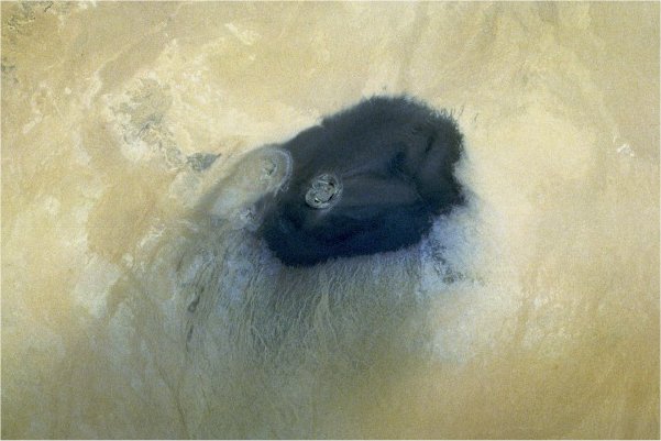
Wau Namus
Resolution: 150 metres (approx.) A near vertical Space Shuttle photograph of Wau Namus in south central Libya. The large central caldera is clearly visible, with sicke shaped lakes around the indistinguishable central cone. The adjacent crater to the North-west is also distinct. The main caldera is about 5 kilometres wide, while the black ejecta covers an area over 25 kilometres in diameter. |

![]()