 Ascent of Jebel Uweinat
6th November, 2001
Bernhard Lörsch, András Zboray
After a warm mug of coffee and a couple of well-wishes, we set out in darkness just before 5am from our camp, lying near the end of the drivable section of Karkur Ibrahim, at an elevation of 600 metres. The southern cross, lying on it's side, was brightly visible over the dark peaks. With the half moon behind us, it was bright enough to make out all features as we made our way along the sandy bottom of the wadi among the sparse akacias towards the point where it entered the foothills, about two kilometres from camp. We were carrying the barest necessities in our backpacks - four 1.5 litre water bottles (counting for a possible night on the mountain in case one strains an ankle, or worse
), a little dried fruit and biscuits, film, camera, and a sweater.
Soon the two sides closed in, and we continued on a gently rising, winding narrow wadi, with increasingly bigger granite boulders littering the bed. At one turn, we passed under an akacia with a huge branch lowering to ground level then rising and lowering again in a huge inverted U shape - "al bab al Uweinat". It soon became difficult to find a path among the boulders, which became car size by now, and on several occasions the steep loose rocky sides of the valley proved the best going.
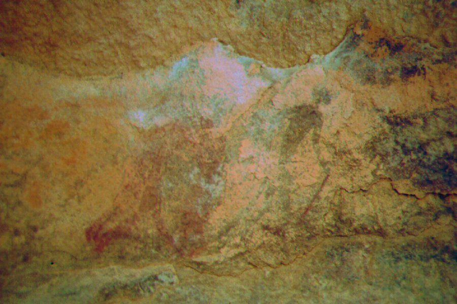
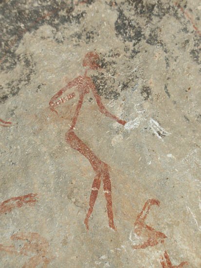
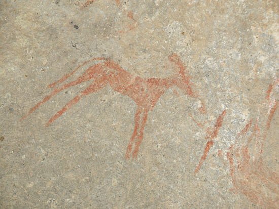
Dawn came rapidly, and just before sunrise we came upon a small rock shelter lying some 20 metres above the wadi floor on the southern side. On close examination, we found faint traces of painted human figures, however the true wonder came when crawling in, in a little hollow in the ceiling, we found a lovely small group of paintings in bright, vivid colors, as if painted yesterday. The large decorated female figure is quite unique, as is the location, at an elevation of 800 metres, high above the main valley floor.
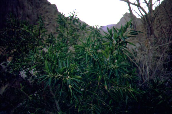
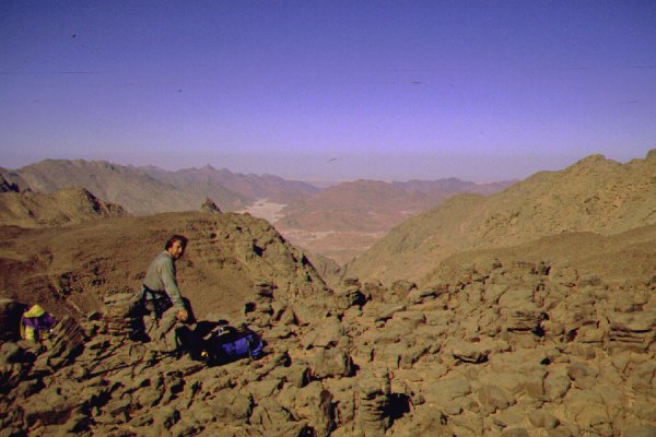
Continuing from the shelter the valley began to rise more steeply, and it became a rather difficult scramble among the gigantic boulders and rocks. We soon met the first Ficus tree that only survives at shaded higher altitude spots of Uweinat - a tree with bright green long leaves, much like an olive, with abundant yellow fruit. We passed several along the way, all along shaded turns of the now narrow canyon. At the point where the wadi forked, three hours from camp, we made our first water depot, leaving one of our four 1.5 litre bottles under a rock. We took the left fork, continuing towards the main mass of the mountain, still looming high above us.

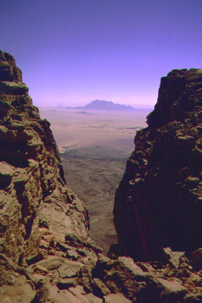
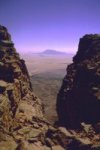
After a further kilometre the valley ended in a narrow gorge with perpendicular rock walls rising over a hundred metres on both sides. There was a dry guelta at the entrance of the gorge, probably deep and sheltered enough to hold water for a few years after rains. Beyond the gorge was blocked by a large boulder wedged between the walls, we had to find an alternate way. A steep ravine filled with a rockslide gave the only way up the canyon walls, and after a half hour scramble we emerged on the slopes of the granite double peak looming above the two western Karkurs. We continued along the hillside parallel to the now hidden watercourse, until on ascending a ridge we found ourselves only a little above the now again gently sloping wadi, some 200 metres above our starting point
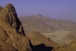
Following the wadi bed, we soon came to the dividing line between the granite and sandstone parts of the mountain. It really is a sharp line, to the west the solemn grey rocks and boulders, to the east the familiar golden hue of the sandstones. The going became easier too, as the smaller and more angular sandstone blocks now composing the streambed gave a much easier footing than the huge rounded granite boulders. As we continued, the wadi started to veer right, towards the lesser peaks of the sandstone cap. However we wanted to get to the small plateau at the foot of the main cliffs that we scouted from a hil near our camp the evening before. We had no choice but to turn towards the loose slope, at the top of which we were hoping to find a sandstone plateau gently sloping towards the cliffs.
Our senses were proven right, and shortly we were standing at the edge of a scarp, the first in a series of low steps that led all the way up to the main cliff. At 10am we sat down to rest in the shade of a big rock just below the start of the cliff, the last 300 metre obstacle till the peak. It was curious to note that we were not the first humans there. Near the rock, we found the broken shards of the neck of a glass bottle, quite old judging from the thickness and style. Probably we were sitting on the direct path used by the Tibou natives from Karkur Ibrahim to Karkur Talh, the plateau being the watershed between the two.
We left another two bottles under the rock, and started for the final ascent. We surveyed all the narrow ravines that came down the cliffs, and one of them offered a possible but dangerous looking route up over very steep, loose rubble. We decided to take a peek behind a turn of the cliff nearby, whether there might be a better route. Soon another ravine came into view, much like the other one, but here the very steep section seemed to be limited to 20-30 metres. Though it was nearing midday, the ravine was still almost completely in the shade, a substantial aid in the ascent. By this time we both consumed one full bottle of water, and the half of the second one, more than two litres.
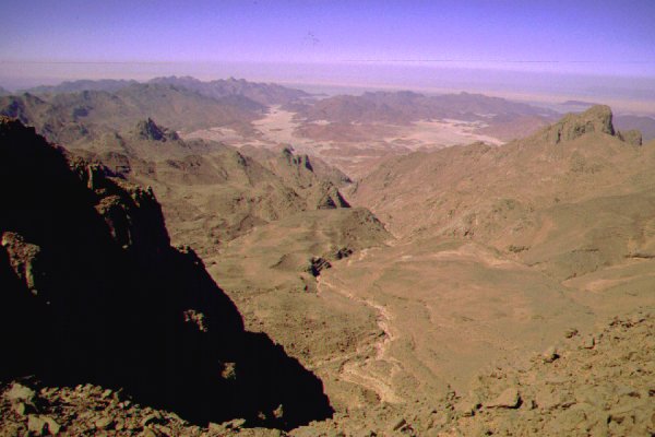
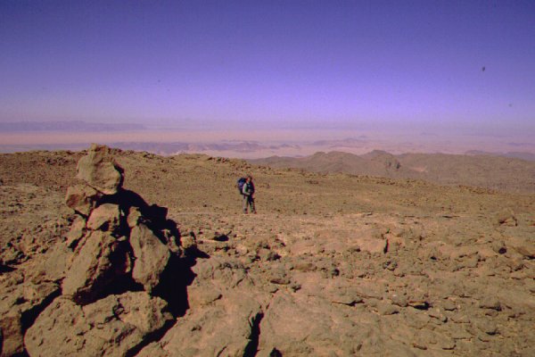
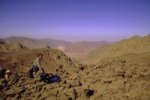
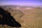
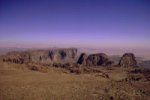
In retrospect, the climb proved to be much easier than thought. Aside a 20 metre stretch of near vertical rock, fortunately with plenty of good hand and footholds, the rest was just a steep walk up the rubble, occasionally having to pull oneself over a larger rock or a narrower spot. It took no more than 40 minutes to be up at the top, or almost top, in a maze of small wadis and eroded rock pillars. However from here it was an easy going to the true top of the plateau, and by 11:30 we sat on the edge of the cliff, our legs dangling into the abyss, with Karkur Ibrahim and the whole western part of the mountain far below us.
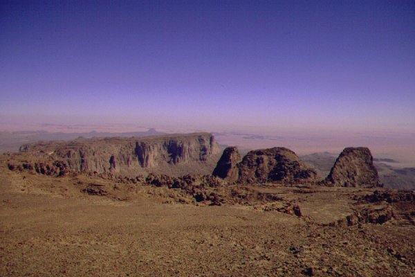
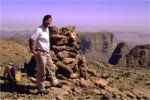
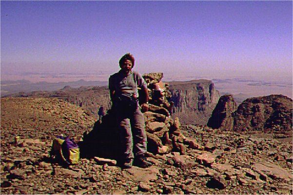
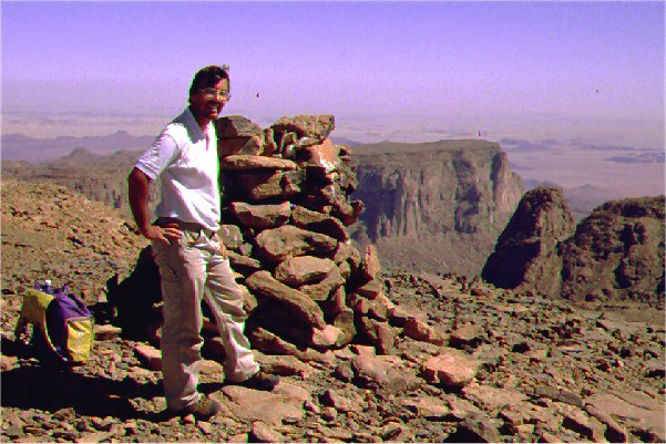
This was not yet the true peak. The top of the mountain is a dissected undulating plateau, with some parts lying a few metres above the rest. The perspective is misleading, we several times reached a height presumed to be the true 'peak', only to find another gentle rise beyond just a bit higher. We soon realized, that it will be difficult to retrace our steps even with GPS, and started building small alams (cairns) to guide us to the descent on the return. From one of the rises we finally spotted the large cairn marking the spot reached by Bagnold in 1932 - it was on the far eastern end of the plateau, some 3 kms away, we reached it by 12:30.
The cairn was not marking the actual peak, it was offset by about 20 metres, and about two metres lower. Later reading Bagnold's acount, it became clear that they built the cairn so it will be clearly visible from the plain to the south. We measured the actual peak with GPS to be 1912 metres altitude. The cairn contained a small glass jar with some dates and a very brittle looking paper inside, and a soup powder tin with a german and french label. Both were too corroded to be opened on the location without damage, we decided to take them to be opened and examined with proper care. After some photos and a short rest, we started our way back at 1pm, our agreed return time irrespective of where we are at that time.
On our way back we checked our altitude on the highest looking rise along the western part of the plateau (from where we first spotted the cairn), which was more evident now, coming from a distance. It proved to be the true summit, at an altitude of 1932 metres, lying exactly on the 25th longitude, the border between Libya and Sudan. To our surprise, this verified the claim of Captain Marchesi, who reached the top of Uweinat from the west like us in the spring of 1933, a few months after Bagnold & Shaw. Marchesi named the high point (measured to be 1934 metres) Pico d'Italia, and placed it just inside Italian territory. Previously it was assumed that Pico d'Italia is the same point as that reached by Bagnold, lying well inside Sudan.

The wiew from the cliff to the west was still breathtaking, but we had no time to linger and enjoy for too long. Both of us knew well that the descent will take almost as much as the ascent, and the sun will go down at 5:30. Stumbling along those huge boulders in the wadi bed in pitch darkness did not sound like a too good proposition. We retraced our course, and descended the ravine along the cliff face. Soon we reached our water depot by the rock, and noted that we hardly needed more than a quarter of a bottle each for the climb and the return. A climb in the shade, the reduced load and the flat plain above made all the difference.
The descent along the stepped plateau was actually more difficult than going up. The loose rubble always started rolling under one's feet, and much energy was wasted keeping one from sliding and falling. The lengthening shadows urged us along, but it was a loosing race. By four we just reached the point where we had to leave the wadi and scramble along the hillside above the canyon. As we started the descent inside the ravine back to the wadi bottom, sunlight left us, and it was a gloomy grey twilight at the bottom. We reached the first water depot before sunset, still a good 6-7 kilometres from camp, with the worst of the boulders ahead of us.
With a little rest we raced on, as fast as the now very sore knees and blistered feet allowed us. As long as there was twilight we could still make out the best route requiring the least scrambling, but soon darkness fell, and we were left to follow the general watercourse, our torches were too faint to gain a full picture of the surroundings. This last hour and a half was the worst, climbing up a torch lit boulder boulder, then down the other side, then repeating without end, only seeing the next few immediate footsteps. The only consolation was the backlighted screen of the GPS, which told us reassuringly, that slowly, much too slowly, we were getting ever closer to camp.
Finally the boulders became scarcer,the akacias denser, and it was a huge relief to be able to actually walk again in the soft sand of the wadi bed. We stumbled in to camp at 8pm, exactly 15 hours after start at dawn.
We have managed to quell our impatience, and kept the two containers unopened until we arrived home.
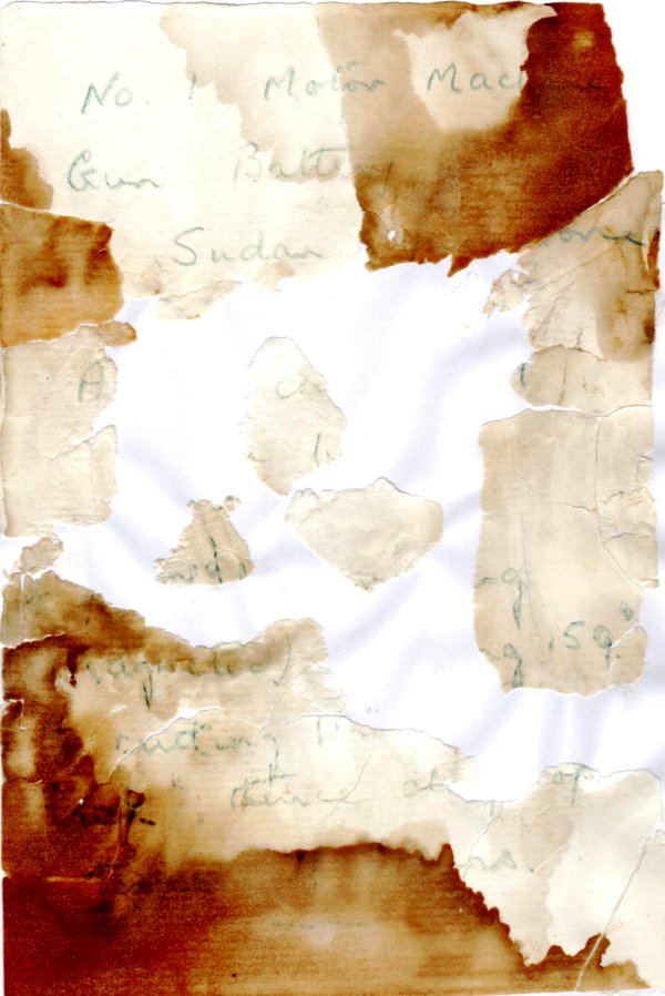
The glass bottle contained a note from the No. 1. Motor Machine Gun Battery of the Sudan Defence Force. Unfortunately the dates that were put into the bottle stained the paper, and the sealed moisture made it extremely brittle, the centre part turned into dust as soon as it was touched. It was impossible to recover enough to obtain a date or names, but it is very likely that the note was left there by a SDF party who made the ascent in 1934, during the time when the SDF mainatined a permanent garrison at Karkur Murr in response to the Italian's claim on Sarra and western Uweinat.
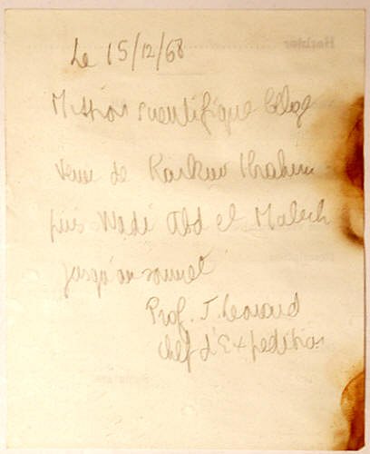
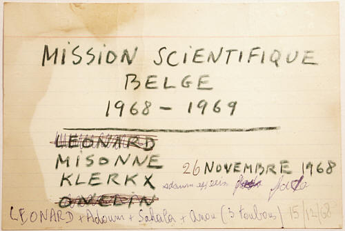
The soup tin contained two notes left by members of the Belgian expedition in 1968, during separate ascents.
Based on the notes and other published sources, we know of five previous ascents of Jebel Uweinat:
- 11th October 1932 - Ralph A. Bagnold, J.E.H. Boustead, D.R. Paterson, W.B.K. Shaw (ascent from south)
- 7th May 1933 - Captain Marchesi, Lodovico di Carporiacco, et al. (ascent from west)
- 1934 February or March(?) - Party of the No.1. Motor Machine Gun Battery, SDF, probably led by Francis Godfrey Bertram Arkwright (presumed ascent from south)
- 26th November 1968 - X. Misonne, J. Klerkx (with chadian porter Adoum) (ascent from south)
- 15th December 1968 - J. Leonard (with three chadian porters, Adoum, Sakhala & Anou) (ascent from west)

 Ascent of Jebel Uweinat