
Geography of the Libyan Desert
The Sahara is diagonally split into a western and an eastern half by a series of highlands. In the West one seldom needs to travel more than 100 kilometres between areas with water and vegetation, and the whole area is well criss-crossed by desert tracks. The eastern half is triangular in shape, bordered on the west by the highlands, the Mediterranean on the north, and the river Nile to the east, it roughly resembles India both in shape and size. This whole vast area, the Libyan Desert, is totally unfit for human habitation. Its central part is a place of extreme aridity, there are periods of 20-30 years with no rainfall. This region was selected by NASA as the earthly region most similar to conditions on Mars during the Viking lander projects. There is no permanent human habitation, no roads or tracks, just the great open void. This explains, why relatively few people do venture into the deeper reaches, as opposed to the western part of the Sahara, where pistes and a denser pattern of oases make travelling easier.
|
Since the second world war the north-eastern part of the Libyan desert, lying in Egypt, is usually referred to as the Western Desert (that is, lying to the west of the Nile). The whole area is composed of a flat plain gently sloping towards the Mediterranean Sea. The tilted rock strata are eroded as the land rises southwards, resulting in a series of scarps that run parallel to the sea, and form cliffs sometimes several hundred metres high. At some points at the base of the scarps the wind has excavated depressions which reach into an aquifyer layer lying under the whole of the Libyan desert, forming oases. |
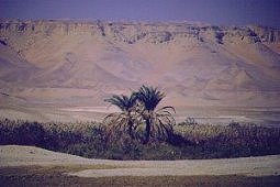
There is a lagre depression, the Qattara depression, just to the south of the northernmost scarp, with Siwa oasis at its western extremity. The depression continues in a shallower form west, to the oases of Jaghbub and Jalo in libya. There are other inhabited oases, Baharya, Farafra, Dakhla & Kharga west of the Nile, all located at the foot of scarps. There are a few scattered uninhabited small oases, usually linked to the major depressions, where water can be found by digging to a few feet in depth. In the west, in Libya, there is a widely dispersed group of oases in unconnected shallow depressions, the Kufra group, consisting of Tazerbo, Rebiana and Kufra.
|
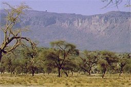
Aside the scarps, the general flatness is only interrupted by a series of plateaus and massifs near the centre of the Libyan Desert, around the convergence of the Egyptian-Sudanese-Libyan Borders. The Gilf Kebir plateau rises about 300 metres above the general plain, and lies entirely in Egypt. It roughly equals Switzerland in size, and is similar in structure to the other sandstone plateaus of the central Sahara. It's South-eastern part is well defined on all sides, with sheer cliffs and deep, narrow wadis. The North-east part, separated from the other half by a broad valley called the "Gap" is more broken, and supports three large wadis with live vegetation. |
|
|
Slightly further to the south are the massifs of Arkenu, Uweinat and Kissu. These granite mountains are very ancient, having formed much before the sandstones surrounding them. Arkenu and Western Uweinat are ring complexes very similar to those in the Air mountains. Eastern Uweinat (the highest point in the Libyan desert) is a raised sandstone plateau adjacent to the granite part further west. The plain to the north of Uweinat is doted with eroded volcanic features. |
|
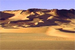
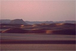
The huge volume of sand excavated by the wind from the Quattara and other lesser depressions have been organised into a huge area of parallel sand dunes, hundreds of kilometres in length, and occasionally reaching heights of a hundred metres. This Great Sand Sea occupies most of the north-eastern part of the Libyan Desert south of Siwa and to the west of Baharya and Farafra, giving way to gravel plains, mudpans and the perfectly flat and featureless Selima Sand Sheet plains further south roughly along latitude 23 North. A tongue of the Great Sand Sea turns west, and continues accross the flat plains in Libya, where it is called the Calanascio Sand Sea. After losing height and tapering off, the dunes gain strength once more, and form the Rebiana Sand Sea that occupies the western edge of the Libyan Desert. |
|
In a small localised area north of the Gilf Kebir plateau one may find chunks of Lybian Desert Glass on the surface between dunes.
|
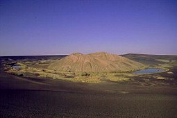
On the plain west of the Rebiana Sand Sea, straddling the border of the Fezzan, one may find one of the greatest natural wonders of the Sahara, the Wau Namus volcano, with it's jet black sand and unreal lakes. |
| SEE ALSO: |
|

|

|

|